Helene tracker: Storm expected to make landfall in Florida as major hurricane

A major hurricane is expected to make landfall in Florida later this week, putting millions of people at risk of high storm surge and flooding.
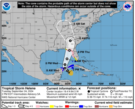
The latest forecast from the National Hurricane Center shows that Tropical Storm Helene is expected to make landfall on the Florida Gulf Coast Thursday as a major hurricane.
The tropical storm is projected to reach hurricane status Wednesday morning before becoming a major hurricane with winds over 110 miles per hour by Thursday morning.
The storm is predicted to make landfall in the United States Thursday night as a hurricane before reverting to tropical storm status Friday morning. After making landfall on the Florida Gulf Coast, models expect the storm to head north throughout the southern U.S. and the Midwest.
The current rainfall forecast shows that the area of the Florida Gulf Coast directly southwest of Tallahassee is expected to receive the most rain from the storm, along with a sliver in the northeast corner of Georgia, a small slice of northwest South Carolina and parts of southwestern and western North Carolina. These areas may see 8-12 inches of rainfall from the storm and isolated pockets of northwest North Carolina and south-central Virginia.
Rainfall could reach between 6-8 inches in the north-central portion of the Florida Gulf Coast as well as the state of Florida itself, including Tallahassee, along with southwestern Georgia, northern Georgia, small pockets of south-central Georgia, northeastern Alabama, southeastern Tennessee, including Chattanooga, western South Carolina, most of western North Carolina and south-central Virginia.
Most of the southern U.S. is forecasted to receive 4-6 inches of rain, including most of the Florida Gulf Coast, northwest and north-central Florida, an area around Jacksonville in the northeast part of the state, most of the state of Georgia, west-central South Carolina, central North Carolina including Charlotte and the westernmost part of the state, much of central and northeastern Tennessee including Nashville and Knoxville as well as most of eastern Alabama including Birmingham and Montgomery.
Southern Kentucky, the southwest corner of Virginia, central Virginia including Roanoke and areas in southeastern Missouri could also see 4-6 inches of rain.
Areas expecting 2-4 inches of rain include central and eastern Florida, including Orlando; as well as the state’s northwest corner; southeastern Georgia, including Savannah; eastern South Carolina, including Charleston; east-central North Carolina, including Raleigh-Durham; central and southwestern Virginia; southern West Virginia; nearly all of Kentucky, western Tennessee and northern Arkansas.
Southern Ohio, including Cincinnati, southern Indiana, southern Illinois, much of western Alabama and southern Missouri, including St. Louis and Springfield, could also see 2-4 inches of rain along with a sliver of northeast Mississippi.
Rainfall could reach 1-2 inches in southwest Alabama, including Mobile, south-central and northwestern Arkansas, small portions of eastern Kansas and Oklahoma and much of Missouri, excluding the northwest portion and the Kansas City area.
South-central Illinois, including Springfield; south-central Indiana, including Indianapolis; southern Ohio; most of West Virginia, excluding the northwest corner; eastern Mississippi; most of eastern North Carolina and most of eastern Virginia, including Richmond, could also see 1-2 inches of rain.
Helene could also bring damaging storm surge to the Florida Gulf Coast.
The highest peak storm surge is forecasted for an area of the Florida Gulf Coast stretching from the Ochlockonee River to Chassohowitzka, where water levels could reach 10-15 feet above sea level. The area between Indian Pass and the Ochlockonee River may experience a storm surge ranging from 5-10 feet, while water levels may reach 6-10 feet between the Anclote River and Chassohowitzka.
The area between the Anclote River and the middle of Longboat Key, including Tampa Bay, could experience a storm surge of 5-8 feet. Storm surge could rise to 4-7 feet in the area between the middle of Longboat Key and Englewood. Water levels could reach 3-5 feet in the area of the Gulf Coast between Englewood and Bonita Beach.
The southernmost portion of the Florida Gulf Coast, stretching from Bonita Beach to the bottom of Florida, could face a storm surge of 2-4 feet. A small storm surge of 1-3 feet is forecast in the portion of the Gulf Coast on the Florida panhandle from Mexico Beach to Indian Pass as well as the Florida Keys. Ahead of Helene’s anticipated arrival, Florida Gov. Ron DeSantis has issued a state of emergency covering 41 of the state’s 67 counties.
Ryan Foley is a reporter for The Christian Post. He can be reached at: ryan.foley@christianpost.com


