Hurricane Milton to slam Florida Gulf Coast as region reels from Helene

Hurricane Milton is expected to make landfall on the Florida Gulf Coast as a major storm as the area continues to grapple with the aftermath and damage caused by Hurricane Helene.
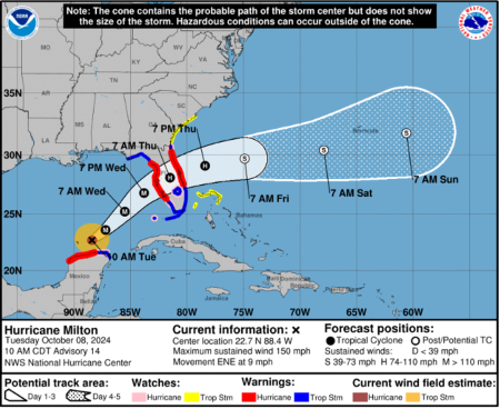
The projected path of the storm, as compiled by the National Hurricane Center, shows that Hurricane Milton is forecasted to make landfall in the central part of the Florida Gulf Coast between Wednesday evening and Thursday morning with maximum sustained winds between 74 and 110 miles per hour. It will move across the state to the Atlantic Coast before heading out to sea at the end of the week. The storm is expected to impact the entire state of Florida with high winds, heavy rain and a major storm surge.
More than a foot of rain is projected to fall in the area of the Florida Gulf Coast directly above Tampa Bay, which is where the storm is currently expected to make landfall. That part of the state, along with an area of the Florida Atlantic Coast directly above Orlando, could see between 12 and 16 inches of rain.
A larger area above both Tampa Bay and Orlando that stretches across the entire state could receive between 8 and 12 inches of rain from Hurricane Milton, as could the area around Tampa Bay. Between 6 and 8 inches of rain are expected in the part of central Florida extending from Tampa Bay to Orlando.
Between 4 and 6 inches of rain could fall in North Central Florida, from the Gulf Coast to Jacksonville, along with the area of the state directly below Tampa Bay and Orlando. Lower rainfall totals between 2 and 4 inches are expected in the Northeast corner of Florida, including Jacksonville, much of South Florida and the extreme Southeast corner of Georgia.
South Central and the Southeast part of Florida, excluding Miami, along with an area stretching from the Northwest portion of the Gulf Coast to Southeast Georgia, will only see 1 to 2 inches of rainfall. Several major cities in Florida, including Tallahassee, are not expected to see significant rainfall from the storm. Rainfall from the hurricane is not expected to impact the Florida Panhandle or the Southeast corner of Florida.
In addition to the impact from rain and wind, coastal Florida could see flooding caused by a massive storm surge. The highest storm surge, which could reach between 10 to 15 feet above ground level, is expected in Tampa Bay as well as an area of the Florida Gulf Coast extending from the Anclote River to Englewood.
Significant storm surge ranging from 6 to 10 feet is expected in the area of the Florida Gulf Coast reaching from Englewood to Bonita Beach. An area further north along the Gulf Coast stretching from the Anclote River to Yankeetown could see similar peak storm surges between 5 and 10 feet. Peak storm surges between 4 and 7 feet are projected for the Southwest portion of the Gulf Coast, from Bonita Beach to Chokoloskee.
Peak storm surges ranging from 3 to 5 feet are forecasted from the southernmost portion of the Florida Gulf Coast from Chokoloskee to Flamingo in addition to the area along the Atlantic Coast stretching from the Volusia and Brevard County lines to the Altamaha Sound in Georgia and a small stretch of the Florida Gulf Coast from the Suwannee River to Yankeetown.
Storm surges of 2 to 4 feet could impact the area from the Volusia and Brevard County lines to the Sebastian Inlet and the portion of the Atlantic Coast from the Altamaha Sound to Edisto Beach in South Carolina.
The Southern tip of Florida extending from Flamingo to the Card Sound Bridge, the Florida Keys, the area of the Florida Gulf Coast stretching from Indian Pass to the Suwannee River and portions of the South Carolina coast from Edisto Beach to the South Santee River could experience storm surges between 1 and 3 feet.
Milton’s expected landfall comes less than two weeks after Hurricane Helene made landfall in the Southeastern U.S., inflicting major damage on much of the region including Florida. Ahead of the storm’s arrival, Florida’s Gov. Ron DeSantis has issued a state of emergency covering 51 of the state’s 67 counties. The state of emergency excludes the 16 northwesternmost counties of the state along the Florida panhandle west of Madison and Taylor Counties.
Ryan Foley is a reporter for The Christian Post. He can be reached at: ryan.foley@christianpost.com


