Hurricane Zeta tracker: Gulf coast prepares for another direct hit

The United States gulf coast is bracing for another direct hit as Hurricane Zeta is forecast to make landfall in the region this afternoon.
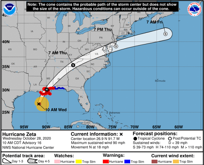
As of Wednesday morning, Hurricane Zeta was located approximately 220 miles southwest of the mouth of the Mississippi River and 235 miles south/southwest of New Orleans, Louisiana. The category 1 storm had maximum sustained winds of 90 miles per hour and was moving north at 18 miles per hour. In anticipation of its arrival in the southeastern United States, the National Hurricane Center, a division of the National Oceanic and Atmospheric Administration, has issued several watches and warnings.
A hurricane warning has been issued for the area stretching from Morgan City, Louisiana, to the Mississippi/Alabama border as well as Lake Pontchartrain, Lake Maurepas and Metropolitan New Orleans. Those living in between the Mississippi/Alabama border and the border between Walton and Bay County, Florida, are under a tropical storm warning.
Storm surge warnings have been issued for the area extending from the mouth of the Atchafalaya River to Navarre, Florida, as well as Lake Borgne, Lake Pontchartrain, Pensacola Bay and Mobile Bay. Lake Borgne and Port Fourchon, both located in Louisiana, could see a peak storm surge ranging from 5 to 7 feet. The peak storm surge could reach as high as 6 feet in Mobile Bay, 5 feet in Lake Pontchartrain and at the mouth of the Atchafalaya River and 4 feet in Pensacola Bay.
A life-threatening storm surge is expected late Wednesday as #Zeta impacts the Northern Gulf Coast. Here is the latest peak storm surge forecast. pic.twitter.com/eFpcaz2xtK
— National Hurricane Center (@NHC_Atlantic) October 28, 2020
Many Americans living along the gulf coast face mandatory or voluntary evacuations as a result of Hurricane Zeta’s imminent landfall. Local officials in Jefferson Parish, Louisiana, have issued mandatory evacuations for the communities of Jean Lafitte, Lower Lafitte, Crown Point and Barataria.
Archie Chaisson, president of Lafourche Parish, Louisiana, has issued a mandatory evacuation for residents and businesses south of the Leon Theriot Floodgate in Golden Meadow and other low-lying areas, including Port Fourchon. Those living in low-lying areas of Terrebonne Parish, Louisiana are also subject to mandatory evacuations. Communities under mandatory evacuations include all of Isle de Jean Charles and parts of Lower Dulac.
The Emergency Management Agency in Hancock County, Mississippi, has worked in conjunction with local officials to issue mandatory evacuations for residents of Bay St. Louis, Waveland, the southern portion of Diamondhead, Clermont Harbor, Lakeshore and Pearlington. Voluntary evacuations have been issued for portions of Plaquemines Parish, Louisiana, Orleans Parish, Louisiana, and Terrebonne Parish, Louisiana.
The governors of states in the path of Zeta have signed emergency declarations in advance of the storm’s arrival. Gov. Tate Reeves, R-Miss., announced on Twitter Wednesday that he had “signed an emergency declaration in advance of Hurricane Zeta.”
I’ve signed an emergency declaration in advance of Hurricane Zeta. Watch the weather. Be prepared.
— Tate Reeves (@tatereeves) October 28, 2020
Emergency operators are working to get ready for storm surge and hard winds—up to 9 feet of surge and winds up to 100 MPH. Stay sharp, stay safe, and pray for God’s protection.
Reeves warned of “storm surge and hard winds” and urged the people of his state to “stay sharp, stay safe, and pray for God’s protection.” Gov. John Bel Edwards, D-La., announced Tuesday that President Donald Trump had approved his request for a federal emergency declaration. Gov. Kay Ivey, R-Ala., signed a state of emergency Tuesday.
Tonight, we learned that @POTUS approved our request for a Federal Emergency Declaration as Hurricane #Zeta heads towards Louisiana. We are grateful for the incredibly fast response. #lagov#lawx
— John Bel Edwards (@LouisianaGov) October 28, 2020
The projected path of Hurricane Zeta shows the storm making landfall in Louisiana this afternoon. By 7:00 a.m. Thursday morning, Zeta will be hovering over the border of Tennessee and North Carolina as a tropical storm.
By 7:00 p.m. Thursday afternoon, Zeta will be located off the coast of New Jersey and will have been downgraded to a post-tropical cyclone. By 7:00 a.m. Friday, the storm will have moved out to sea, located just south of the Canadian coast.
Hurricane Zeta will also bring substantial rainfall to the gulf coast and much of the eastern half of the U.S. Between 4 and 6 inches of rainfall is expected in portions of southeastern Mississippi, southwestern Alabama, northeastern Georgia, western and southeastern Tennessee, western North Carolina, southeastern Mississippi, southern Illinois and southwestern Kentucky.
Southeastern Louisiana, southeastern Mississippi, southwestern and northeastern Alabama, northern Georgia, eastern Tennessee and western North Carolina could see 2 to 4 inches of rainfall.
Similar amounts of rainfall are forecast in much of Kentucky, Virginia, West Virginia, Maryland, Delaware and New Jersey, the southern portions of Kansas, Missouri, Illinois, Indiana, Ohio and Pennsylvania, and the northern parts of Oklahoma and Arkansas. Over the next 48 hours, much of the eastern seaboard, including New York City, could see 1 to 2 inches of rainfall from Zeta.


